Press ![]() on the right-hand keypad on the steering wheel and say one of the following commands:
on the right-hand keypad on the steering wheel and say one of the following commands:
- “Navigation” – Initiates a navigation dialogue and shows examples of commands.
- “Take me home” – Guidance is given to the Home position.
- “Go to [City]” – Specifies a city as a destination. Example “Drive to London”.
- “Go to [Address]” – Specifies an address as a destination. An address must contain city and street. Example “Drive to 5 King’s Road, London”.
- “Add intersection” – Starts a dialogue where two streets must be specified. The intersection point of the specified streets then becomes the destination.
- “Go to [Post code]” – Specifies a post code as a destination. Example “Drive to 1 2 3 4 5”.
- “Go to [contact]” – Specifies an address from the phone book as a destination. Example “Drive to Robyn Smith”.(In order to find addresses in the map database, they must have been entered correctly in the phone book, e.g. without spelling mistakes and abbreviations. Go to wego.here.com for spell checking.)
- “Search [POI category]” – Searches for adjacent points of interest (POI) within a certain category (e.g. restaurants).(The user has the option of calling the POI or specifying it as a destination.) To have the list sorted along the route – say “Along the route” when the results list is shown.
- “Search [POI category] in [City]” – Searches for points of interest (POI) within a certain category and city. The list of results is sorted according to the city’s central point. Example “Search for restaurant in London”.
- “Search [POI name]“. Example “Search Kielder Forest”.
- “Change country/Change state(In European countries, “Country” is used instead of “State”.)(For Brazil and India, the search area is changed via the centre display.),” – Changes the search area for navigation.
- “Show favourites” – Shows saved positions in the driver display.
- “Clear itinerary” – Erases all the stored intermediate destinations and final destination in an itinerary.
- “Repeat voice guidance” – Repeats the last spoken guidance.
- “Turn off voice guidance” – Switches off voice guidance.
- “Turn on voice guidance” – Starts the switched-off voice guidance.
The following commands can generally be used, regardless of the situation:
- “Repeat” – repeats the last voice instruction in the ongoing dialogue.
- “Help” – starts a help dialogue. The system replies with the commands available in the current situation, a prompt or an example.
- It is possible to stop voice control both when the system is silent and when it is speaking.
- “Cancel” – stops the dialogue when the system is silent.
- Give a long press on
 until two beep tones are heard – the dialogue stops, even if the system is speaking.
When an address is entered, the search area is defined as the search area preset in the navigation system. It is possible to switch to a different search area. If the new search area uses a different language to the selected system language, the system will automatically switch to a different recognition engine. Therefore, state the address in the language used in the new search area.
Note that addresses can only be searched for the country or state that the navigation system is preset for. To search for addresses in another country or state you first need to change search area.
Activating navigation
- Navigation system tile
- Home button
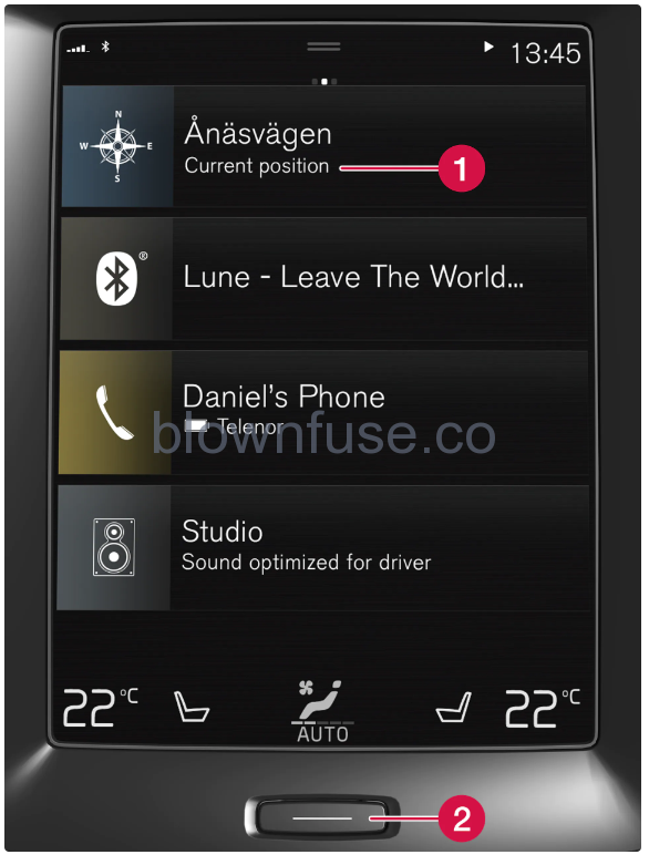
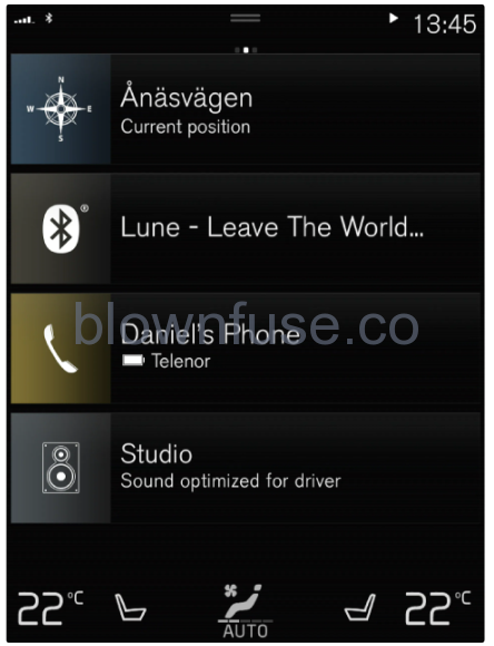
Show the map image in the centre display by tapping on the top tile (1) on the home view. If the centre display does not show the navigation system tile – press briefly once on the home button (2) and then tap on the navigation system (1) tile. Then a map of the current area is shown with the car symbolised by a blue triangle.

Press on this symbol to show the map image across the entire centre display.
Observe the following.
- Direct all your attention to the road and make sure that all your concentration is on driving.
- Follow applicable traffic legislation and drive with good judgment.
- Due to weather conditions or time of year affecting the road conditions, some recommendations may be less reliable.
The navigation system cannot be switched off but always works in the background – it is only switched off when the driver locks and leaves the car.
The navigation system is also available when the engine is switched off. When the battery level gets too low the system switches off.
Here you can find an introduction on how to start to use voice control in order to control the navigation system in the car.
To activate a navigation command
Press the voice control button on the steering wheel ![]() .
.
You can now give commands, e.g. “Navigation” that start a navigation dialogue and show examples of commands.
NoteNot all system languages support voice recognition. The ones that do are highlighted with the ![]() symbol in the list of available system languages. Read more about where the information can be found in the section on settings for voice recognition.
symbol in the list of available system languages. Read more about where the information can be found in the section on settings for voice recognition.
Use voice control to get directions to an addressTo get directions to a specific address, use the spoken command Go to followed by the address. The order in which the address is given is important. To get directions to an address via voice control, the address must be given in the following order: (1) street address; (2) street number; (3) city; according to the following example:
- Give the Go to command.
- Now you can give the address you want directions to.
- Give the street address, e.g. “King Street”
- Give the street number, e.g. “Five”
- Give the city, e.g. “Gothenburg”
- In this case, the combined command will then be: “Go to King Street Five, Gothenburg”. Provided the address is found in the system, you will now get directions to the address via your navigation system.
Use voice control to get directions to an address in another country or another countyYour navigation system installs sets of maps for the country or county where the car recognises its location. This means that in order to get correct directions across country or county borders, you need to first tell the system the country or county in which your desired destination address is located. You do this by using the Change country or Change state command. (The Change state command is primarily used in USA. The Change country command is used in the example below.)
- Give the Change country command.
- Now you can give the country for the address to which you want directions, e.g. “Norway”.
- Now give the address to which you want directions by following the same procedure as in “Use voice control to get directions to an address”.
- In this scenario, the combined command will be divided into 2 subcommand:
- “Change country, Norway”
- “Go to Karl Johans gate twenty two, Oslo”
- Provided the address is found in the system, you will now get directions to Karl Johans gate 22, Oslo, Norway via your navigation system
- In this scenario, the combined command will be divided into 2 subcommand:
After changing country, try to pronounce the address you want directions to in the language of the destination country. This is necessary since the system’s recognition changes automatically to the language of the selected country.
Use voice control to get directions to an address given as Home positionIf you have given an address in your navigation system as a Home position, you can use a spoken command to get directions to the position. Give the Take me home command. If the navigation system has a home position saved, you will now get directions to the position.
You can use your navigation system to get directions to special places or a specific type of business, so-called points of interest (POI). Examples of points of interest are, for example, restaurants, hotels, petrol stations, museums or sights and landmarks. You use the Search command to search for a point of interest. You can search for both a specific point of interest as well as point of interest categories.
It is important which command you choose to use for obtaining directions to different alternatives. Please note that when you want directions to a point of interest, use the Search command. This is different from when you want directions to specific addresses. Then the Go to command must be used instead.
Search for a specific place or business[POI name] here refers to a specific place or business, a so-called point of interest, e.g. a hotel, a restaurant, a municipal park, etc.
- Give the Search command.
- Now you can specify a specific point of interest you want directions to.
- State [POI name], e.g. “Castle Forest”
- In this case, the combined command will then be: “Search Castle Forest”. Provided the place is found in the system, you will now get directions to the place via your navigation system.
Search for a point of interest category e.g. shops, hotels, restaurants, museums or other sights and landmarks or businesses[POI category] here refers to specific types of place or business, so-called points of interest, e.g. hotels, restaurants, museums, etc.
- Give the Search command.
- Now you can specify the type of point of interest you want to find and get directions to.
- State [POI category], e.g. “restaurant”
- In this case, the combined command will then be: “Search restaurant”. The navigation system will now search for restaurants located near and around the car, which results in a list in your driver display. The list that appears consists of suggestions the system has produced based on your command. Categories and close results are at the top, and the lower the relevance a suggestion is deemed to have, the lower down the list it appears.
- Since you are looking for a category in this example, it may be a good idea to choose the category option closest to your search.
- Select the category most appropriate for your search target in the list, in this case “restaurant(s)”, by speaking the number of the row in which the option appears in the driver display.
- Now you can see your search results and select an option that suits you.
Use voice control to stop directionsIf you want to stop directions and all of the intermediate destinations and the final destination, this can be done with a spoken command. Give the Clear itinerary command. The navigation system stops the directions and deletes all of the intermediate destinations and the final destination along the travel itinerary.
How to give postcode and house numberThe number commands are stated differently depending on the function to be controlled:
- Postcodes must be spoken individually, number by number, e.g. zero three one two two four four three (03122443).
- House numbers can be spoken individually or in groups, e.g. two or twenty-two (22). For some languages, it is also possible to state them with hundreds, e.g. 19 hundred 22 (1922). For English and Dutch, several groups can be said in sequence, e.g. twenty-two (22 22). For English, double or triple can be used, e.g. double zero (00). Numbers can be given within the range 0-2300.
(Option/accessory.)
When calculating a route, several factors are taken into account to determine the theoretically best solution. Factors include route distance, road width, road classification, traffic intensity and speed limits. However, an experienced driver with local knowledge can quite possibly select a better route.
The navigation system shows the position of the car to an accuracy of about 20 metres (65 ft). There is a greater risk of error when driving on roads lying parallel to another road, on winding roads, on roads with several levels and after driving a long distance without making any distinctive turns. High mountains, buildings, tunnels, viaducts, over/underpasses etc. also have a negative effect on the reception of satellite signals, which means that accuracy in calculating the position of the car may decrease.
Calibration takes place when you lock the car and allow it to remain locked for 15-30 seconds. If the problem with incorrect position persists following calibration, contact a workshop to check/calibrate the antenna unit.
The position of the car on the map is incorrect after transportation
The car symbol on the screen behaves illogically after the tyres have been changed
In addition to the satellite receiver, the car’s speed sensor and a gyroscope assist in calculating the current position, speed and direction of travel of the car. After fitting the spare wheel or changing between summer and winter tyres the system needs to “learn” the size of the new wheels. In order that the system shall function optimally it is therefore recommended that the car is driven for a while on roads with good satellite reception (good visibility).
Factors such as the constant expansion and rebuilding of the road network, new traffic regulations constantly being introduced etc. mean that the map database is not always, in every situation, complete. Because of this the map data is being constantly developed and updated – check now and again to see if there are any updates.
The system may need a few seconds to sense the position and movement of the car before driving off. Switch off both the system and the engine. Start again, but remain stationary for a while before starting to drive.
See the answer under the next heading.
Map data are updated and improved continuously. In connection with map updates via computer and USB, the current map version in the car can be shown. Check the map version in the car and compare with the available map version in the support information on volvocars.com.
Activate Real Time Traffic Information (RTTI)(Real Time Traffic Information) in order to continuously retrieve information on traffic congestion, road closures and other events that may affect journey time. The car must be connected to the Internet where there is coverage in order to continuously retrieve traffic information.
(Option/accessory.)
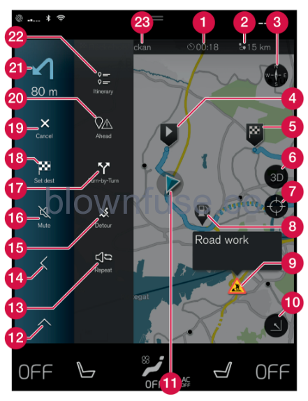
| Symbols and buttons on the map | |
| 1 | Arrival time/remaining travel time |
| 2 | Distance to destination |
| 3 | Compass/changes between north and travel direction up |
| 4 | Starting |
| 5 | Destination/final destination |
| 6 | Changes map display between 2D and 3D |
| 7 | Reset the map to follow the car |
| 8 | Point of interest (POI) |
| 9 | Traffic information |
| 10 | Minimises (expanded view) or maximises the map image (full screen) |
| 11 | Car on planned route |
| 12 | Minimises the tools field |
| 13 | Repeat the current voice guidance |
| 14 | Minimises the tools field |
| 15 | Calculate detour |
| 16 | Voice guidance temporarily On/Off |
| 17 | Shows list with the itinerary’s guidance points |
| 18 | Specifying destinations/intermediate destinations |
| 19 | Cancels guidance |
| 20 | Shows list of the itinerary’s points of interest (POI) and traffic information |
| 21 | Next manoeuvre |
| 22 | Itinerary and Alternative route |
| 23 | Destination/final destination |
PLEASE READ THIS END USER LICENSE AGREEMENT CAREFULLY BEFORE USING THE HERE DATABASE.
THIS IS A LICENSE AGREEMENT – AND NOT AN AGREEMENT FOR SALE – BETWEEN YOU AND HERE EUROPE B.V. (“HERE”) FOR YOUR COPY OF THE HERE NAVIGABLE MAP DATABASE, INCLUDING ASSOCIATED COMPUTER SOFTWARE, MEDIA AND EXPLANATORY PRINTED DOCUMENTATION PUBLISHED BY HERE (JOINTLY ”THE DATABASE”). BY USING THE DATABASE, YOU ACCEPT AND AGREE TO ALL TERMS AND CONDITIONS OF THIS END USER LICENSE AGREEMENT (”AGREEMENT”). IF YOU DO NOT AGREE TO THE TERMS OF THIS AGREEMENT, PROMPTLY RETURN THE DATABASE, ALONG WITH ALL OTHER ACCOMPANYING ITEMS, TO YOUR SUPPLIER FOR A REFUND.
The Database and the copyrights and intellectual property or neighboring rights therein are owned by HERE and its licensors. Ownership of the media on which the Database is contained is retained by HERE and/or your supplier until you have paid in full any amounts due to HERE and/or your supplier pursuant to this Agreement or similar agreement(s) under which the Database is provided to you.
HERE grants you a non-exclusive license to use the Database for your personal use or, if applicable, for use in your business’ internal operations. This license does not include the right to grant sub-licenses.
HERE warrants that, subject to the warnings set out below, for a period of 12 months after acquisition of your copy of the Database, it will perform substantially in accordance with HERE’s Criteria for Accuracy and Completeness existing on the date you acquired the Database; these criteria are available from HERE at your request. If the Database does not perform in accordance with this limited warranty, HERE will use reasonable efforts to repair or replace your non-conforming copy of the Database. If these efforts do not lead to performance of the Database in accordance with the warranties set out herein, you will have the option to either receive a reasonable refund of the price you paid for the Database or to rescind this Agreement. This shall be HERE’s entire liability and your sole remedy against HERE. Except as expressly provided in this section, HERE does not warrant nor make any representations regarding the use of results of the use of the Database in terms of its correctness, accuracy, reliability, or otherwise. HERE does not warrant that the Database is or will be error free. No oral or written information or advice provided by HERE, your supplier or any other person shall create a warranty or in any way increase the scope of the limited warranty described above. The limited warranty set forth in this Agreement does not affect or prejudice any statutory legal rights that you may have under the legal warranty against hidden defects. If you did not acquire the Database from HERE directly, you may have statutory rights against the person from whom you have acquired the Database in addition to the rights granted by HERE hereunder according to the law of your jurisdiction. The above warranty of HERE shall not affect such statutory rights and you may assert such rights in addition to the warranty rights granted herein.
The price of the Database does not include any consideration for assumption of risk of consequential, indirect or unlimited direct damages which may arise in connection with your use of the Database. Accordingly, in no event shall HERE be liable for any consequential or indirect damages, including without limitation, loss of revenue, data, or use, incurred by you or any third party arising out of your use of the Database, whether in an action in contract or tort or based on a warranty, even if HERE has been advised of the possibility of such damages. In any event HERE’s liability for direct damages is limited to the price of your copy of the Database. THE LIMITED WARRANTY AND LIMITATION OF LIABILITY, SET FORTH IN THIS AGREEMENT, DO NOT AFFECT OR PREJUDICE YOUR STATUTORY RIGHTS WHERE YOU HAVE ACQUIRED THE DATABASE OTHERWISE THAN IN THE COURSE OF A BUSINESS.
The Database may contain inaccurate or incomplete information due to the passage of time, changing circumstances, sources used and the nature of collecting comprehensive geographic data, any of which may lead to incorrect results. The Database does not include or reflect information on – inter alia – travel time and may not include neighborhood safety; law enforcement; emergency assistance; construction work; road or lane closures; road slope or grade; bridge height, weight or other limits; road conditions; special events depending on the navigation system brand you possess.
This Agreement shall be governed by the laws of the jurisdiction, in which you reside at the date of acquisition of the Database. Should you at that moment reside outside the European Union or Switzerland, the law of the jurisdiction within the European Union or Switzerland where you acquired the Database shall apply. In all other cases, or if the jurisdiction where you acquired the Database cannot be defined, the laws of the Netherlands shall apply. The courts competent at your place of residence at the time you acquired the Database shall have jurisdiction over any dispute arising out of, or relating to this Agreement, without prejudice to HERE’ right to bring claims at your then current place of residence.
(Option/accessory.)
All settings for the navigation system are defined via the centre display. Here, the driver sets how the map is to be displayed or enters a destination. If the map image is not shown in the centre display – tap on the top tile (for the navigation system).
What geographic position does the car have now? Press the map’s car symbol (blue triangle) – the information is shown directly on the map.
Find the car symbol on the map

After zooming in and out and moving around on the map, it can sometimes be hard to find your way back to the position of the car. Press the crosshairs to reset the map to follow the car symbol.
North or direction of travel upwards on the map
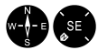
There are two ways of showing the car’s movement in relation to the map. Press the symbols to switch between having north or the direction of travel upwards on the map. When the map is shown with north upwards, the car symbol moves in the current compass direction on the map. If the car symbol moves to the left on the map, the car is driving westwards. When the car symbol is pointing upwards, the map rotates under the car symbol, depending on how the car is turning. The compass symbol points towards north (N) on the map, and the centre of the compass shows the direction in which the car is pointing:
| Compass symbols | Compass direction |
|---|---|
| N | North |
| NE | Northeast |
| E | East |
| SE | Southeast |
| S | South |
| SW | Southwest |
| W | West |
| NW | Northwest |
2D or 3D display

Tap on the symbols to shift between 2D and 3D display. For 3D display, the car’s direction of travel is always shown upwards. The map rotates under the car symbol, depending on how the car is turning. The compass symbol indicates which direction north is (N) on the map, and the centre of the compass shows the direction in which the front of the car is pointing. The map scale is not shown in 3D mode. For 2D display, the map is shown with north upwards, and the car symbol moves in the current compass direction on the map.
Make the map larger by tapping the centre display twice in quick succession or by placing two fingers on the centre display and separating them outwards.
Zoom out from the map by tapping once with two fingers on the centre display or dragging two fingers together on the centre display.
Place one finger on the map, swipe in the desired direction, and release. The scroll function is only possible with the map maximised, not minimised.
Maximise the map and press on the map heading at the top of the centre display. Choose between the following displays as the heading on the map:
- Destination Destination, arrival time (ETA) or remaining travel time (RTA) and distance to destination (Distance). To select ETA or RTA, see the section “Settings for route and road navigation”.
- Current position as address (Address) or as coordinates (Coordinates). When coordinates are shown, altitude is also shown (Altitude). To choose between address and coordinates, see section “Map settings”.
The navigation system is presented and operated in several different ways, e.g. via the driver display.
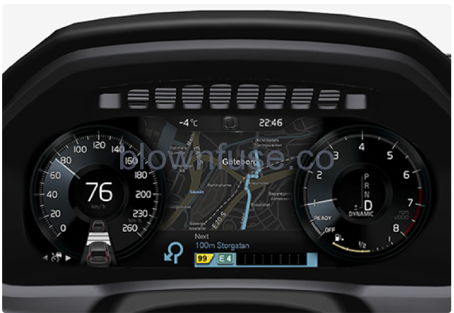 The map is only shown in the 12″ driver display.
During driving the driver is guided by voice guidance and instructions on the driver display. Map display in the driver display can also be activated without a set destination.
The right-hand steering wheel keypad and the driver displayThe right-hand steering wheel buttons can be used to manage some of the functions in the navigation system, e.g. Take me home and Cancel guidance. If a message is shown the driver display, it must first be acknowledged or dismissed for the menu to be shown.
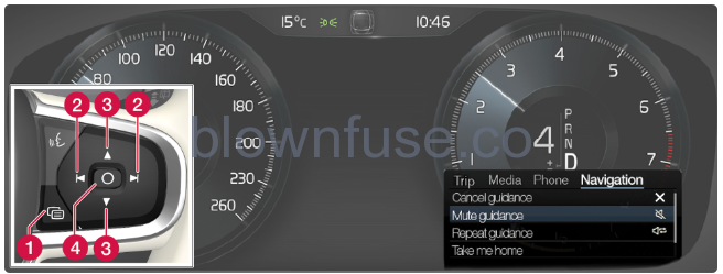
- Opening/closing the menu. The menu is closed automatically after a period of inactivity or with certain options.
- Browsing between menus.
- Browsing between menu options.
- Confirm or highlight an option.
The navigation system is shown automatically in the driver display when a destination is set. The navigation system can also be shown without specifying a destination.
- Drag down the centre display’s top view.
- Press Settings.
- Press .
- Press the radio button Show Map to show the navigation system in the driver display without an entered destination.
Suggest new map information with Map Creator
If your Volvo is equipped with Sensus Navigation, maps from the Here map supplier are shown. If you find that any information is missing from a map, or want to suggest changes, you can do this at Here‘s Map Creator service. Such information can include new addresses or rerouted roads.
- On Here‘s Map Creator service, you can create an account to log in and suggest map changes. Instructions for how to do this are also found there.
- The changes you suggest are sent to Here for review. Once the information has been verified and approved, the information you suggested is added to their maps. The changes will be available in your Volvo after your suggestion has been approved by Here and implemented in a map update that you then install in your navigation system.
- Suggestions for changes that are reported are reviewed and checked thoroughly before Here approves them and adds them to their maps. It can take up to twelve months before the changes reach the maps in your car.
Volvo does not have the opportunity to verify, approve or implement the requests for map changes you send to Here.
Traffic information providers
Information on which companies deliver traffic information to your car and its systems in different countries is found below.
| Region | Country | RTTI | RDS-TMC | Sirius XM | VICS | T-DMB |
|---|---|---|---|---|---|---|
| Africa | South Africa | INRIX | ||||
| Asia | China | INRIX | ||||
| Indonesia | INRIX | |||||
| Japan | VICS | |||||
| Korea | KBS | |||||
| Singapore | INRIX | |||||
| Thailand | INRIX | |||||
| Europe | Austria | INRIX | ||||
| Belgium | INRIX | |||||
| Czech Republic | INRIX | |||||
| Denmark | INRIX | |||||
| Finland | INRIX | |||||
| France | INRIX | |||||
| Germany | INRIX | |||||
| Hungary | INRIX | |||||
| Italy | INRIX | |||||
| Luxembourg | INRIX | |||||
| Netherlands | INRIX | |||||
| Norway | INRIX | |||||
| Poland | INRIX | |||||
| Portugal | INRIX | |||||
| Russia | INRIX | |||||
| Slovakia | INRIX | |||||
| Slovenia | INRIX | |||||
| Spain | INRIX | |||||
| Sweden | INRIX | |||||
| Switzerland | INRIX | |||||
| Turkey | INRIX | |||||
| UK | INRIX | ITIS | ||||
| Middle East | Bahrain | INRIX | ||||
| Kuwait | INRIX | |||||
| Oman | INRIX | |||||
| Qatar | INRIX | |||||
| Saudi Arabia | INRIX | |||||
| The United Arab Emirates | INRIX | |||||
| North America and Central America | Canada | INRIX | ||||
| Mexico | INRIX | |||||
| USA | INRIX | |||||
| Oceania and Pacific Ocean | Australia | INRIX | ||||
| New Zealand | INRIX | |||||
| South America | Brazil | HERE |